Urban Park, Europan 9


Project: Urban Park, Europan 9
Locatie: Groningen
i.s.m. Marcel Westers
The general concept for the urban design of the entire site is to compress the built square meters into dense clusters (URBAN) in order to create room for clusters of open space (PARK). These open spaces breathe the atmosphere of the current wasteland and they will strengthen the image of the dense urban texture and vice versa; Appreciation by contrast. To maximize the contrast between the dense and open spaces, a checkerboard pattern is used, creating a diverse and dynamic urban design that alternately opens up and closes.
___________
The open space in phase 1 is the harbour, placing the dense urban cluster naturally at the bottom of the site; at the same time creating a boundary wall between the busy new Sontweg and the more quiet harbour. In phase 2 and 3 the open spaces are actual wasteland-like parts, increasing in size and atmosphere towards Meerstad.
Each area has it’s own urban identity, without being designed specifically for a certain group or type of people. People will not be told where to live. The urban and architectural conditions should be strong enough to create a characteristic feel of that specific area and combined with available facilities create an area people experience as valuable.
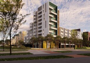
Whereas the area of phase 3 is reaching towards the green zone between Meerstad and the N46, the houseboat harbour is the area’s face towards the city. Without building high-rise structures, the design responds to the large scale urban settings of the intended develop-ment areas along the Eemskanaal towards the city centre, and the large scale Sont-bridge across the water creating the connection to the centre. Along the Sont-bridge a large grid-structure is placed in which several volumes are positioned at different levels. In doing so, a wall is created, separating the busy traffic from the small scale houseboats.
Towards the harbour quay the urban scale of the housing volumes is reduced in two steps. This creates vistas and thus maximizes the view on and the awareness of the houseboat harbour and the Eemskanaal. Walking through the dense urban part of phase 1 there is a constant open relation with the water. By routing the traffic circulation via an elevated road over the public level, the route from front door to water edge is uninterrupted public space. At the same time, a route scenic is created for the cars, providing a spectacular experience and giving access to all the building blocks in the scheme.
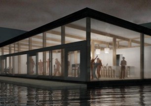
By folding the quay line the experience of living right at the quay is maximized and a dynamic pedestrian area along the water is created.


Leave a Reply